An Open Letter to the Planning Board and City Council (4/11/23):
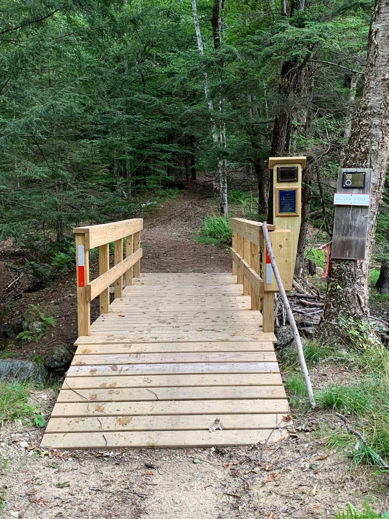
It has come to our attention that Mayor Nicholson intends to prepare for development two certain parcels of city land off of Rte 140 in Gardner. NCLT is a direct abutter to M47-22-4 with our Rome Conservation Area. Old Eaton Street is partially contained within these parcels and is, and has been, used for recreation by many for generations. The memorial bridge over Wilder Brook is on M47-22-4 rebuilt in 2019 by Eagle Scout, Jack McDermott is on this land.
M47-24-1 is almost entirely wetland and abuts the Winchendon-Gardner rail trail. When you’re on that section of rail trail, this parcel is the big wetland that you cross that is just unbelievable for bird and wildlife watching.
The highest and best use of these lands is for conservation, water resource protection, and passive recreation, as has been the case for many years. Developing these lands would destroy public values that cannot be replicated. The potential increase in tax revenue is small compared to the costs to the community.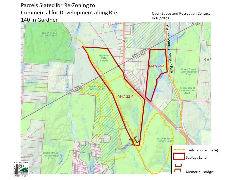
According to the Mayor’s Proposal, the intention of this action is:
- To change the zoning from Rural-Residential to Commercial/light industrial in this area along 140, targeting specifically these two parcels
- To increase tax revenue by selling these city-owned parcels to private entities for commercial development adding $12,228 in real estate tax revenue annually
- To increase future tax revenue by encouraging commercial development and therefore being able to collect business taxes (variable depending on development type and the incentives)
- To be able to improve traffic safety by necessity as the commercial development is built out, accessing state funds available for that
- To add jobs via the commercial development
There are a number of issues with the Mayor’s proposal.
The Mayor’s main argument for this re-zoning is that commercial development would be better for this area vs. 129 building lots which would add to the traffic danger. This assumes that the land could be developed at all.
For decades these parcels have been mapped as, and assumed to be, protected open space lands as they are adjacent to and provide supporting landscape for the Gardner City Forest and Watershed Land. These permanently protected lands are critical in providing superior water quality for the city, saving the city millions in water treatment costs. It is included in the 2011 Forest Managment Plan for the Perley Brook Reservoir Forest as part of the Reservoir’s forestland. It is included in Gardner’s Open Space and Recreation Plans, listed as “Permanently Protected” land.
Water Supply
The parcels have been labeled as Watershed Land for decades. Until it is discovered that it was intentionally NOT set aside for this purpose, it should be assumed that this parcel was intentionally put into that category as a supporting landscape to the watershed and is protected under Article 97.
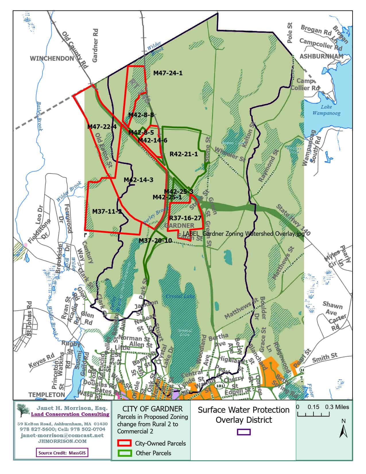
Portions of this land are in the Watershed Overlay district.
The purpose of the Surface Water Protection Overlay District is to:
(1) Promote the health, safety, and general welfare of the community by ensuring an adequate quality and quantity of drinking water for the residents, institutions, and businesses;
(2) Preserve and protect existing and potential sources of drinking water supplies;
(3) Conserve the natural resources of the City; and
(4) Prevent temporary and permanent contamination of the environment.
Bailey Brook, whose watershed is partially within this area, is a cold water fishery which is very sensitive to environmental changes and inputs.
The Mayor is of the opinion that these parcels, though labeled as Watershed Land are not actually watershed land.
- “As such, even though Parcel M47-24-1 is located fully within this overlay district and a small portion of Parcel M47-22-4 is located in the overlay, it is the determination of the Administration that this does not make these parcels watershed lands as they still do not meet the definitions for watershed land by the City, Commonwealth, and Federal government. Rather, they are simply further regulated on what can and cannot be done on the areas of these parcels that are included in the Surface Water Protection Overlay District.” – page 10 (12) of the Mayor’s proposal
If this is the case, why was the land mapped and labeled as such for so long and on so many city approved plans and documents? Most likely, city leaders who were involved in protecting the watershed and drawing up the overlay district, understanding the value of the habitat and natural resources in this region, indicated that designation for a reason. There has not been sufficient evidence to prove the land is NOT under Article 97 protection of the State’s Constitution which states:
The people shall have the right to clean air and water, freedom from excessive and unnecessary noise, and the natural, scenic, historic, and esthetic qualities of their environment; and the protection of the people in their right to the conservation, development and utilization of the agricultural, mineral, forest, water, air and other natural resources is hereby declared to be a public purpose.
The general court shall have the power to enact legislation necessary or expedient to protect such rights.
In the furtherance of the foregoing powers, the general court shall have the power to provide for the taking, upon payment of just compensation therefor, or for the acquisition by purchase or otherwise, of lands and easements or such other interests therein as may be deemed necessary to accomplish these purposes.
Lands and easements taken or acquired for such purposes shall not be used for other purposes or otherwise disposed of except by laws enacted by a two thirds vote, taken by yeas and nays, of each branch of the general court.
M47-24-1 is almost entirely wetland and abuts the Winchendon-Gardner rail trail. With wetland and perennial stream setbacks, this land is not suitable for development.
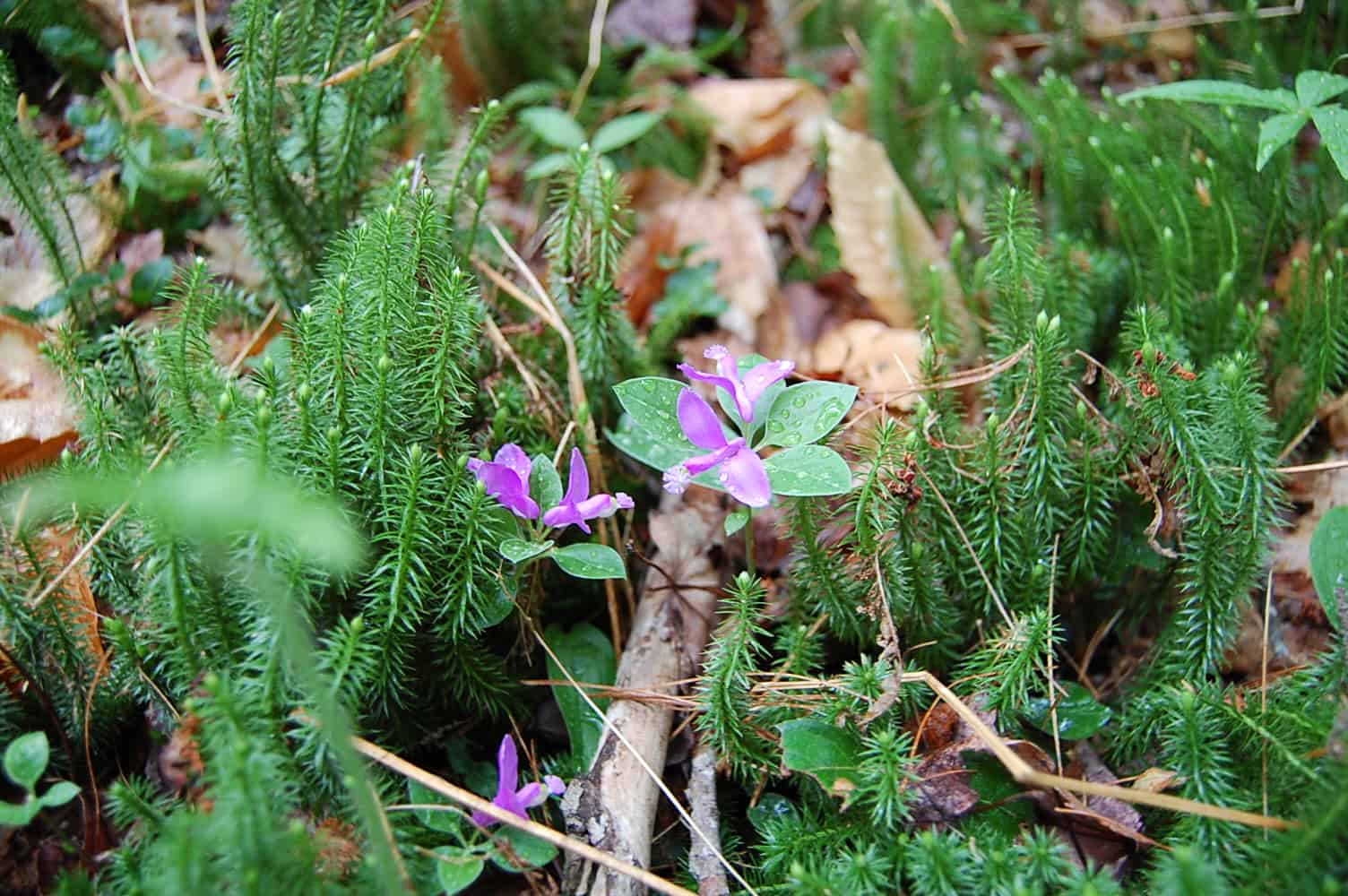
In addition, this area is one of the few places in town that has been mapped as Outstanding Water Resource Area, Critical Natural Landscape and Core Habitat by Mass Wildlife in their BioMap 3, 2022 update. MassWildlife and The Nature Conservancy released the newly-updated BioMap tool in November 2022. The BioMap web portal delivers the latest scientific data and resources to help state and local governments, land trusts, non-government organizations, and other conservation partners strategically plan projects to conserve wildlife and their habitats. The latest version of BioMap combines more than 40 years of rigorously documented rare species and natural community records from MassWildlife with cutting-edge climate resilience data from The Nature Conservancy and spatial data identifying intact fish and wildlife communities, habitats, and ecosystems that are the focus of the Massachusetts State Wildlife Action Plan.
There is a reason why so much of Gardner’s conservation land is in this area of the city. It is an important natural landscape for the city, the region, and the state. The land has long been mapped as part of Gardner’s watershed protection land and has been mapped as “Permanently Conserved” in Gardner’s Open Space and Recreation Plans. Portions of this land are also within the Watershed Overlay District.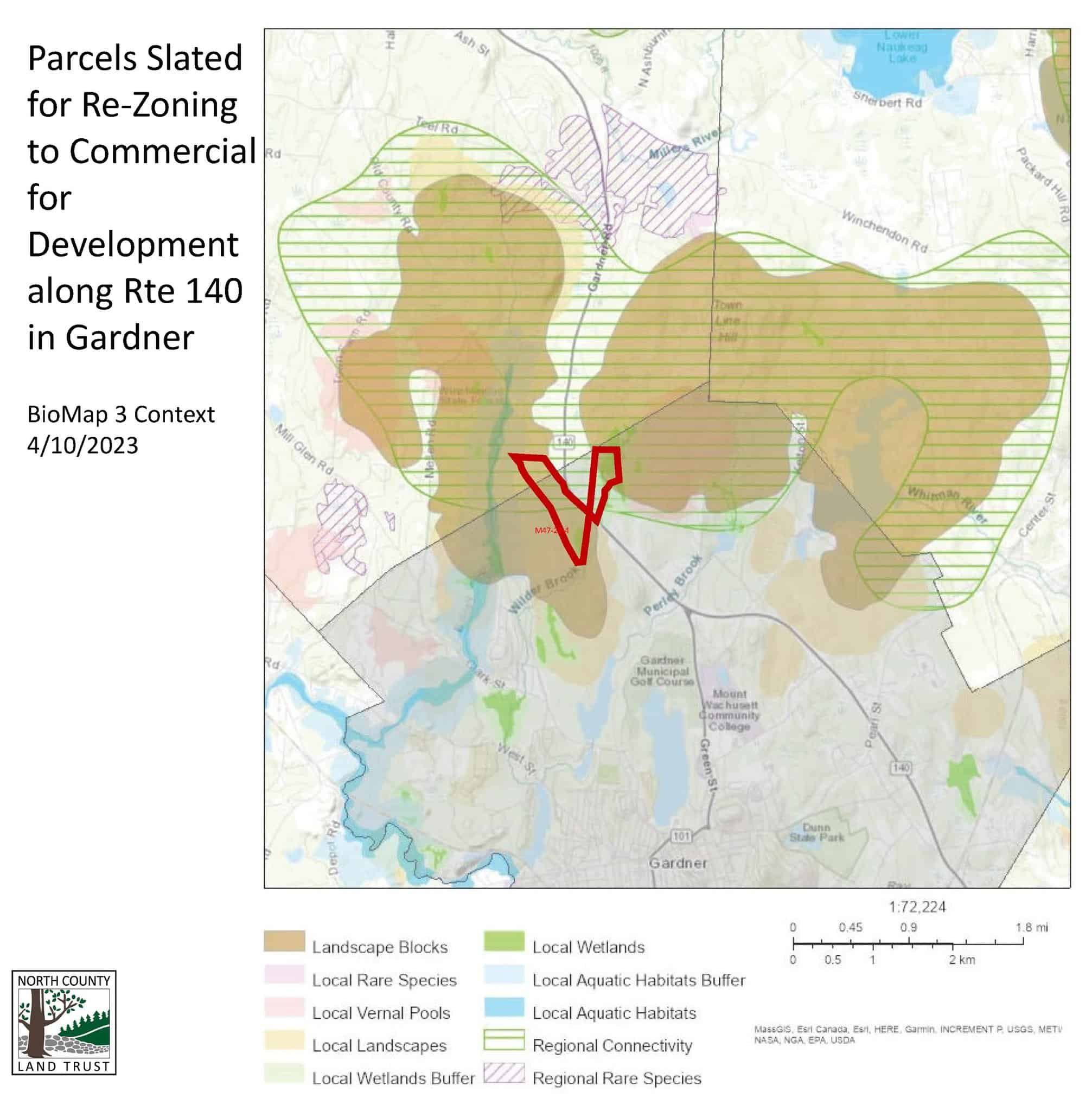
NOT SUPPORTED BY THE MRPC PLANS.
Data does not support Mayor’s claims of MRPC’s recommendation for this land as being appropriate to develop along Rte 140.
The 2010 MRPC report, Route 140 North Corridor Buildout Analysis Gardner, Westminster, And Winchendon, Massachusetts, did not cover the area now being proposed for re-zoning.
Map 2, page 14 of this report shows the land the that covers M47-22-4 is shown as “Undevelopable”
The 2011 MRPC report, Phase 2 Route 140 Overlay District Project–Gardner And Winchendon, Massachusetts states on page 2.
-
-
- “Gardner
1. The City has enough land zoned for commercial development, especially when considering the number of old mills that are vacant and potential candidates for commercial uses.” - “6. Much of the northern portion of the Rt. 140 Corridor is in the City’s water supply watershed, which allows low density residential development. There is little support for allowing new commercial or industrial development due to potential threats of contamination.”
- “Gardner
-
COMMUNITY CONTEXT
In the 2011 MRPC report, Page 25 shows a map of the Winchendon Overlay district which is not contiguous with the development district of Gardner showing isolation of any development in this area which would make it “Spot Zoning”, which is illegal. The Rt. 140 Commercial Overlay district in Winchendon does not begin until the Hillview Industrial Park.
Winchendon has chosen to protect the rural, residential and agricultural southern entrance to the community as illustrated in the recent protection of Sunset View Farm .
The Health Equity Partnership of North Central MA (CHNA9) released their 2023 Policy Priorities. They included a climate justice category. Several relate to this proposed rezoning.
The CHNA9 acknowledges the interconnectedness of climate change, biodiversity loss and environmental/social justice and supports policies that prevent further increases in global temperatures, that decrease land degradation and the catastrophic loss of biodiversity, and that prioritize addressing impacts on and involvement with historically marginalized and oppressed communities. Policies include those that:
Instigate and promote community efforts to identify climate adaptation and mitigation as critical for future wellbeing
Assist our communities, businesses, and organizations in developing plans and programs to reach the 2030 and 2050 Goals outlined by the Commonwealth…
Promote increased tree canopy coverage in urban areas to mitigate heat island effects; filter and clean water and air; and create safe spaces that promote mental health and well-being
Policies that require renewable energy systems to be sited on disturbed or built environments rather than natural landscapes and which provide clear benefits to our region including the use of local labor and access to the energy savings produced by the projects.
Traffic
We all agree that traffic and traffic safety is an issue on Rte 140 but the Mayor compares development of this parcel for single family housing vs. commercial development which assumes development at all. Yes, some aspects of Commercial development would be favorable in a traffic sense to some aspects of single family housing but, NO additional traffic demands here would benefit the traffic situation even more.
Development
The large scale commercial and retail industry markets have changed dramatically due to online shopping and work from home options. People are moving back to walkable small cities and towns. Here are Smart Growth Applications: https://www.epa.gov/smartgrowth/about-smart-growth or the way it is used for the increasing number of organizations working on strengthening our small cities.
HIGHEST AND BEST USE
The land in this proposal has been mapped by MassWildlife through their BioMap3 as being in both Core Habitat and Critical Natural Landscape.
There are only 3193 acres of this type of designated land in Gardner. Not all of it is protected. And some of it is developed. This designation is important for our Natural resources, habitats, bio-diversity and resilience to climate change, more-so than other areas in town.
If we’re talking about highest and best use, we should mention the current use, which is not mentioned. The highest and best use for these lands is for open space and recreation for the identity of Gardner and Winchendon.
We are not saying we shouldn’t have more commercial development in Gardner. We are not saying that we don’t need more housing. We are saying, these 177 acres are better suited for opens space than commercial or residential development. The land has a use now, is being actively used by our residents (tax paying, fur bearing, and otherwise) and the development of which would have a negative impact on tangible and intangible benefits to the City.
We urge the planning board and city council on behalf of our hunters, outdoor enthusiasts, and species that can’t speak for themselves, to consider this land too important as open space to be considered as developable land. Let it serve our community as it has for decades, evidence by our assumption that it was protected land. Then I urge the city to seek permanent legal protection, if not already in place, so our city forest lands can remain intact, impactful, and further unfragmented.
Thank you.
Anna Wilkins, Executive Director
Call your Gardner City Council Member
Sign our Petition: https://chng.it/RPRVYdQBqG
Planning Board’s March 20 hearing https://www.youtube.com/watch?v=UZYiC7DHVSA
and March 29th deliberations https://www.youtube.com/watch?v=jbyrzBNLHdc&t=3s
https://massland.org/naturesvalue
https://www.massaudubon.org/valueofnature
UPDATE: 4/14/23 In response to an email we sent to the mayor yesterday we received this reply this morning—“I wanted to write to you to let you know that as a way to alleviate any procedural concerns and to allow for more time for greater feedback, I have submitted a request for a leave to withdraw the item from the City Council agenda. In plain English, this means that the Council moves to take the item off of the agenda.” – excerpt from Mayor Nicholson’s email from 4/14/23
This is good news but we still need to keep the pressure on. We need for Mayor Nicholson to abandon any ideas of development here, commercial or otherwise, and we need to ask that the city council re-affirm all of the city-owned Open Space, mapped as permanently protected in the 2015 OSRP, as Open Space protected under Article 97, to ensure that we are not re-visiting this topic in years to come.
They Mayor has been very forthcoming and responsive to our communications and concerns. The city councilors we’ve spoken to have also been open to our message. We thank them all for their service to Gardner and for their consideration.
UPDATE: 4/28/23
City Council Members Heath, Boone, Tyros, Tassone, and Hardern are sponsoring the mayors plan to change the zoning at the city council meeting this Monday, May 1st, 2023. This is much sooner than expected.
If you are in one of these wards, please contact your ward councilor. The zoning change does not, in and of itself, mean the land WILL be developed. However, it does mean that is the intent of these city leaders to pursue that end.
We are against any and all development on these parcels for the sake of the City Forest, Wilder and Bailey Brook, and the recreation and open space values of these parcels that have been recognized and affirmed by generations.
While the Mayor is convinced this land is not subject to Article 97 protection, we are not convinced. Based on information I received from Mayor Nicholson, the commercial interest that have inquired about this land include: Marriott, Home Depot, Lowes, and the Suffolk Downs Racetrack developers.
This or ANY development on these specific parcels would have and outsized negative impact on the intact habitat and natural resources block that serves the city, and would diminish home and land values for abutters.
The Planning Board and Planning Director do not support development on these parcels. NCLT will be watching this, talking to city reps, and preparing to fight any proposals to sell or develop this land. Please join us! You can always reach us at info@northcountylandtrust.org. Considering supporting us with a donation. Thank you for your Attention and Support! -NCLT Board and Staff
UPDATE: 5/1/23 City Council, discusses if the way the zoning was reintroduced at City Council might constitute an Open Meeting Law Violation due to the fact that the letter introducing the packet, which all 5 sponsoring committee members signed, expresses an opinion supporting the zoning changes. City Council votes to ask the legal department to send over a legal opinion.
UPDATE: 5/10/23
Legal Opinion is delivered to the City Council President:
“Despite the fact that the letters were not drafted by any member of the City Council, the signatures of each Councilor on the letter constitute an affirmative statement of that Councilor’s opinion. These letters were then distributed to the entire City Council in its meeting packet. This distribution constituted a communication of an opinion to a quorum of the City Council outside of a duly noticed public meeting. It is therefore, the Law Depanment’s opinion that each of the letters submitted by the five Councilors constitutes a violation of the Open Meeting Law.
In order to remedy this matter. the Law Department recommends the following steps be taken:
- Each of the letters be withdrawn from consideration
- The City Council vote to self-report the violations to the Commonwealth or Massachusetts Attorney General’s office; and
- The Council refrain from any future communication or an opinion by one or more members or the Council outside of a duly noticed public meeting by any means.”
UPDATE: 5/15/23
City Council Voted to remove Items 10972, 10973, and 10974 from the calendar and authorize the city council president to work with the legal department on self reporting to the Attorney General office.
Councilor Judy Mack commented that while the items have been removed for now, they will likely be reintroduced at a later date, which is yet undetermined.
City Council Meeting Recording (Min. 34:34-38:40)
UPDATE: 8/3/2023
Gardner City Council Agenda and Packet for Monday, August 7, 2023 at 7:30PM
Petition 11043, Page 92 in the City Council Packet
City Councilman Dana Heath is proposing “AN ORDINANCE TO AMEND THE CODE OF THE CITY OF GARDNER, CHAPTER 675
THEREOF, ENTITLED “ZONING,” TO CHANGE THE CLASSIFICATIONS OF CERTAIN
PARCELS OF LAND ALONG ROUTE 140.”
UPDATE: 8/22/2023
Planning Board Meeting at Gardner City Hall
- Postponement of Rezoning
- [Minutes still not released as of 26 August]
- -video: https://www.youtube.com/watch?v=ihyufMGe-vs
Media coverage of Planning Board Meeting breaks before midnight
- CBS Boston Gardner residents working to stop horse racing track before it gets to starting line
- Gardner News/Telegram & Gazette A horse racing facility is before the Gardner Planning Board: Here’s why it delayed a vote
- Gardner Magazine- https://gardnermagazine.com/2023/08/23/planning-8-22-23/
UPDATE: 8/31/2023
-
- He notes that Zoning is not a change in use so Article 97 does not prevent the change in Zoning
- However he finds that “parcel M47-24-1 consists of all wetlands, namely Wilder Brook, and is not viable for development of any kind, residential or commercial. Verification of this only requires a simple visual inspection and walk along the North Central Pathway. It is unclear to the Law Department why parcel M47-24-1 is included in the zoning petition for the
above-stated reasons“ - For M47-22-4,
- “The legislative record contains clear statements of purpose for the taking, and the 1937 Council used funds from the Gardner Water Department’s Land Purchase Account to pay for the land.”
- The Law Department was unable to locate any subsequent legislative action in which this Prior Public Use was abandoned. “…engineering plans were located for the layout of Route 140 in the early l 970’s. These plans identify the Parcels as City of Gardner, Water Department land.”
- “It is the Law Department’s opinion that Article 97 and the Public Lands Protection Act apply to the Parcels and will govern any future change in use sought by the City”
- He notes that Zoning is not a change in use so Article 97 does not prevent the change in Zoning
- The letter goes on to inquire:
- if the City Council intends to pursue a change in use of the subject parcels in full compliance with the Public Lands Protection Act regardless of whether the zoning is changed.
- If so, then the Council should engage in a robust analysis of the PLPA requirements
- and whether or not there is any likelihood of the Commonwealth of Massachusetts approving any desired change in use of these Parcels or granting an exception to the PLPA and if so,
- the cost to the City in complying with the PLPA. This analysis should be conducted as a threshold analysis before any zoning change is considered
- if the City Council intends to pursue a change in use of the subject parcels in full compliance with the Public Lands Protection Act regardless of whether the zoning is changed.
UPDATE : 9/1/2023
Gardner Magazine https://gardnermagazine.com/2023/09/01/parcels-protected/
Mayor’s Update: (min. 7:45) https://youtu.be/zfEB2REaXtw?si=eJBBdXwaF65arN0o